Projects | Experience that counts

As GIS consultants with over 25 years in the industry, we provide quality GIS consulting services & expertise in engineering GIS solutions that fit your needs.

city of riverside

2020 - 2021

The City of Riverside, subcontracted with Psomas and Eckersall in 2020 to create three new web GIS viewers using ArcGIS Server, Portal, and Geocortex technologies. The City has a massive collection of GIS data which had been migrated from ArcInfo 7.x to ArcSDE 10.x in a previous Task Order. Our project was the creation of all web-based mapping viewers to replace the original ArcInfo viewers. This project was completed 100% remotely, including interaction with many City staff. 

Our tasks for this project included:

  • Organize and conduct User Requirements meetings
  • Record User Requirements and logically group them to set milestones
  • Develop a System Design
  • Publish over 500 layers from the new geodatabase to ArcGIS Server and Portal
  • Develop custom Geocortex workflows and reports to automate many City tasks
  • Create the following Viewers using Geocortex:
    • An in-house GIS Viewer for City staff
    • An in-house Utility GIS Viewer for City Water & Electric staff
    • A public GIS Viewer
  • produce over 11 hours of training video for City staff & IT administrators

placer county water agency

2019 - present

Placer County Water Agency contracted with Eckersall in 2019 to migrate their internal web mapping solution from ArcGIS Flex Viewer to Geocortex. The Agency also identified a need to assist with migration of the underlying geodatabase from MapBox and PostgreSQL to a new ArcSDE geodatabase in Microsoft SQL Server. Our engagement was expanded to include this data migration, conversion of all nightly scripts, connectivity to the HTE system data, and advanced reporting using SQL Server Reporting Services. The original project is complete and the new web GIS has been in production since October, 2020. This has been a challenging and rewarding project, particularly the conversion of complex PostgreSQL views, functions, and nightly procedures to SQL Server. In December, 2020 the Agency signed a contract with Eckersall to continue to provide on-call GIS Consulting services through December, 2024. Thus far, the Agency has relied upon Eckersall to provide responsive technical support, assist IT staff with issues or questions, and add new features to the web GIS tool.

  • Location Mapping: researching and geocoding home and business broadband customer locations

  • Automated production of nationwide KMZ files by county showing funding-eligible census blocks

  • Advanced analysis and estimation of location counts per census block

  • Utility line buffer analysis to determine impact of various proposed alternatives

Moss Adams

2019 - present

Moss Adams has contracted with Eckersall since 2019 to provide the following GIS Consulting Services, primarily supporting various Universal Service Fund (USF) rural broadband build-out initiatives:

  • Location Mapping: researching and geocoding home and business broadband customer locations

  • Automated production of nationwide KMZ files by county showing funding-eligible census blocks

  • Advanced analysis and estimation of location counts per census block

  • Utility line buffer analysis to determine impact of various proposed alternatives

Western municipal water district

2019 - present

Western Municipal Water District (WMWD) has contracted with Eckersall since March, 2019 to perform a number of updates to its Geocortex Essentials sites.  Geocortex leverages the power of ArcGIS Enterprise to provide powerful and customizable web mapping applications.   WMWD utilizes this technology for a public Meter Request site, mapping for internal users, and internal handling of the Meter Request process.

The following updates have been completed thus far:

  • ArcGIS Server, ArcSDE, and SQL Server maintenance and tuning

  • Geocortex application development including Reports, Printing, and Workflows

  • Public and Internal web application updates

  • Development of automated Python tools

City of Costa Mesa

2017 - present

We serve as onsite and remote GIS consultants and have completed the following:

  • ArcGIS Server, ArcSDE, and SQL Server maintenance and tuning

  • Geocortex application development on the ArcGIS Server platform

  • Web applications for public use

  • Development of automated Python tools

city of Norwalk

2016 - present

Eckersall has worked with Norwalk’s Public Services Department providing GIS consulting services to create their Water GIS. Prior to, water maps were in AutoCAD format and depicted facilities at a very high level. 

In order to produce a highly accurate and usable GIS, we used a combination of GPS, as-built or design construction plans, maps, meetings with field staff, and other sources dating back to the 1930’s. Photos were also taken of each water system component. This included meters, valves, hydrants, interconnects, water monitoring stations, and air vacs.

Norwalk’s Public Services Department also contracted Eckersall to update the existing Sewer GIS. At the time, gravity mains and manholes were accurate to 30-50 ft. Since, we have improved accuracy to 10-20 ft.

City of Sierra Madre

2003 - present

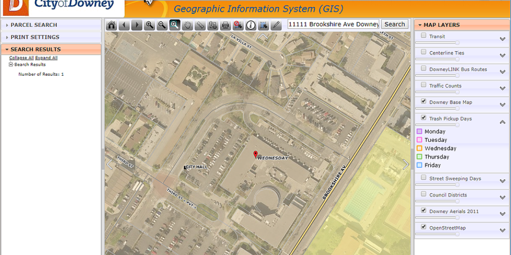
The City has been a client since signing up for the XY•MAPS service in 2003.  Staff use XY•MAPS each day to look up properties, view City-maintained infrastructure, open linked documents from the City’s network, and create maps and reports.

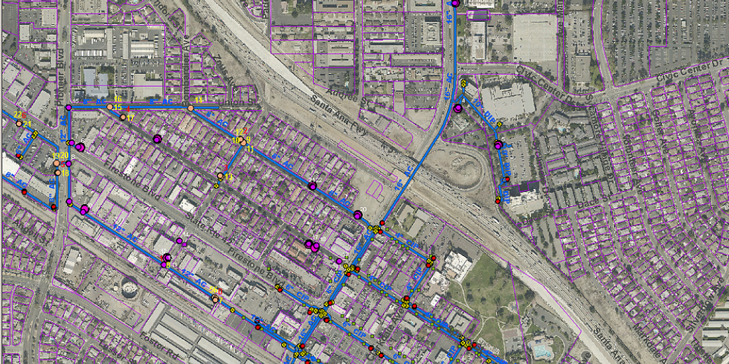
In 2016, the City of Sierra Madre tasked Eckersall with updating its Water GIS layers. To do this, we performed field GPS of updated and new valves or meters. Furthermore, mapping updates of any new or updated mains were applied.

There were many inputs including some inconsistent and incomplete maps, plans, drawings, and first-hand field staff knowledge.  Eckersall was able to synthesize all of these and combine GPS data collection to create a more accurate set of GIS data. 

city of downey

2015 - present

Norwalk’s Public Services Department also contracted Eckersall to update the existing Sewer GIS. At the time, gravity mains and manholes were accurate to 30-50 ft. Since, we have improved accuracy to 10-20 ft.

Eckersall georeferenced approximately 16,000 engineering drawings, linking them to features in XY•MAPS. For example, water and sewer mains are clickable, and linked to all relevant drawings in which those mains exist. 

Additionally, Eckersall developed custom capabilities to upload and display documents to Laserfiche, directly from the XY•MAPS interface.

Other things completed by Eckersall include: 

  • Configuring a new Windows Server 2008 server with ArcGIS Server 10.2 and ArcSDE 10.2. 

  • Migrated existing ArcGIS Server services from 9.3 to 10.2 

  • Configured a public-facing server with XY•MAPS and set up to use separate open source software (PostGIS and Geoserver)